Today brought weather quite different than the earlier part of the week. Strong winds, overcast sky and rain storms coming and going. Mike took first turn at the helm to get us out from behind the island in Magothy River where we anchored for the night. Arthur and I were on the bow raising the anchor, me on the windlass using hand signals and him with the hose to clean the mud from the rode.
After slowly plowing our way through the chop, all the while avoiding a long string of crab pots, we made it to the mouth of the river and a short while later I took the helm. It wasn’t long before Arthur relieved me and took us the rest of the way across the bay. Half way across the staysail decided it had enough and with lines parting, we furled it for the day.
Once we turned south to head for our home port Jeff got into the action and put the hammer down. Friendship really had a bone in her teeth and somehow Captain Jochen was able to stay composed enough to continue grading tests down below in all the commotion.
As we made our way through the Chester River we spun 180 degrees into the wind and put away the sails for the last time in the trip. Then it was a reverse order of how we departed a week earlier… first to the pump-out, then the fuel dock, and finally back in Friendships berth.
The Burch boys in our element… and our foul weather gear. Conditions finally turned stormy enough before the week passed that it required suiting up. And considering that we shlepped the gear all the way from Kentucky, that was fine.Arthur makes his way back after lashing the anchor to keep it from taking a flying dive off the bowsprit.The dotted line indicates an area of unrecorded tracks, possibly due to lost GPS signals because of the cloud cover, but most likely because I didn’t turn on track recording 😦 Believe me when I say that we didn’t travel that direct of a route before the GPS kicked in.My last time at the helm turned out to be a pretty wild ride. I held on until my fingertips needed unthawing.It got a little exciting as we furled the staysail and reset the genoa.The most-respectable Captain Jochen HoffmannBack at the fuel dock Jochen does a quick debriefing with Tom Tursi from the Maryland School of Sailing and owner of S/V Friendship.As we packed and cleaned the boat Captain Jochen called us all together to present us with certificates for completing the voyage. Mike and I had to grab the evidence and run since our flight was departing in short order. So we planned our route back across the bay once more… but this time our tracks were left by tires.
We began the day knowing that Annapolis was still within our grasp but that we’d still be south of the bridges making for a longer leg back to our home base. We decided to go a bit further north both for reasons of shortening our last leg and because we had not yet had an “anchoring moment”. Seems we were either on the move through the night or conditions were such that we were secured to a dock in a harbor.
Kim is skipper-for-the-day as we prepare for our passage to Magothy River, just across the bay from our home destination.
The engine has been somewhat finicky, wanting to stay in the lower RPM’s to keep from overheating, and with calm winds expected later in the day we figured we better get an early start. We had our fair share of large ships along the way causing for some quick modifications of our course to keep clear.
As we rotate through the one-hour schedule of crew duties (navigator, helm, lookout, deck hand, and assistant navigator) there is also the rotation of dinner preparation. Later tonight will be my time to shine… or fail. Fortunately my wife Janet has assisted me with finding a manageable one-pot concoction that hopefully won’t stretch my un-culinary skills.
Early in this leg is our opportunity to brush up on material to prepare the crew for taking the ASA 106 written test. By the time we reach Magothy River all pencils are down and Captain Jochen is checking papers. Only he knows if diplomas will await us when we return to home base.
It’s 07:00 so we’re on our way. Next stop, Magothy River.Our tracks show that the wind wasn’t going to cooperate to achieve our ideal route.To prepare for the ASA 106 certification Skipper Kim quizzes us on possible test questions.Thinking hard… thinking hard… got it!Ships that pass in the night… I mean day.Mike has eyes on his dream boat (not).Captain Jochen uses the time to get a jump on checking the tests.The sea is getting rather glassy so, with very little hands-on duty needing attention, the education continues.It’s 19:00 and we’re coming up to the William Lane Jr. Memorial Bridges.A view of the twin bridges that you don’t see very often (unless you’re a fish).Not really sure why Mike always seems to have the helm as we navigate the bridge crossings. Just lucky, I guess.Meanwhile, down in the galley I’m preparing the much-talked-about (or worried-about by myself) kielbasa dish with potatoes and peppers. If timing is right it should be ready as we drop anchor in Magothy River. Art suggests adding a glass of wine. Done.Mike works our way through the channel back to Magothy River.Scouting for a spot at 20:15 to anchor before the sun falls.Anchor’s down. Time for that kielbasa dinner.
We began our forth leg after debating whether we preferred doing two legs, leg 4 to Deltaville with leg 5 to Annapolis, or going for the long haul to Solomons Island for another overnight crossing. For myself, getting into and out of the harbors and anchorages is what will prepare me for future day-cruising, more so than sailing into blackness, but considering the timeline and where we needed to be we unanimously opted to go for the distance and save leg 5 for another day. We had to contend with wind on our nose, of course, so our route vs. actual tracks left much to be desired. After some early tacking to make our way to windward it eventually veered enough to straighten us out for much of the trip.
For myself, this leg proved to be far more challenging than going down Delaware Bay and skirting the Atlantic coast. The charts were covered with “prohibited areas” that range from unknown obstructions, to fish havens, to submerged pilings, to sunken wrecks, to areas marked DANGER – UNEXPLODED BOMBS AND SHELLS. And of course there are the pilot areas and shipping lanes to be avoided. All in all, the Chesapeake was an bay of cautions that have built up over centuries of maritime use.
I entered skipperdom at the start of the leg which would have me on my toes for the next 24 hours (now where did I put that cat-o-nine-tails?) with the last half of the leg having Jeff take over as skipper-for-the-day.
Note to self: It’s not “Cape Charles Marina” (the locals apparently hate that distinction) and not “Port Charles Harbor” (which is how I hailed the harbormaster which gained no response). If all else fails, read the freakin’ hand cart!Captain Jochen feeling proud and ready for the next leg after a fine breakfast at the Cape Charles Coffeehouse. Nothing like a bowl of latte to get the gears going.No, it’s not mass seasickness. As we fire up the iron genny to get underway instinct draws everyone to the transom to check the ever-present (hopefully) cooling water exiting with the exhaust.The tracks of our overnight passage from Cape Charles Harbor to Calvert Marina at Solomons Island.Here is what our track looked like as we weaved our way through obstructions near the mouth of the Potomac River (click the image for more detail).The obligatory photo of bowspray as we head for Solomons Island.Yup, they’re out there so we continue to keep a lookout both with our eyes and with the AIS. Later that evening we had two encounters near the shipping lanes that were enough to keep us on our toes.My crew-for-the-day. What a motley bunch, eh?There must be a law against feeling this good. Glad it doesn’t apply offshore.Sunset at 20:30 over the Chesapeake.Another successful overnight passage through Skipper Jeff’s leadership brought us to Solomons Island and Calvert Marina.Our berth at Calvert MarinaWe found Calvert Marina to be a little lonely this particular time of the season. Not to worry though since it meant for faster showers, a less crowded pool, and dining at Back Creek Restaurant mostly to ourselves. That’s S/V Friendship out at the tip of the pier, top center.
Being accustom to Louisville EDT it was surprising for me to see it get light so early on the other edge of the time zone. Captain Jochen had requested a T-head dock so that we could escape in the twilight without disturbing the rest of the marina. Jeff got some coffee brewing and then we were off.
We had the canal to ourselves most of the way which gave us time to look around, but mostly looking up, as we scooted under the bridges.
It’s going to be a long couple of days as we work our way down Deleware Bay and around the tip to Cape Charles. During the 2-day, 230 mile (approx) passage we’re officially going on watch, which means four hour shifts with at least two on deck at all times… a helmsman and a lookout. This also begins the rotation of “skipper-for-the-day”, a 24-hour period that each of us will give directions to his crew regarding departure, transit, meal preparation, and landfall. Jochen thankfully remained as “Captain and coach” and monitored our progress. Skipper Arthur is up first followed by Mike as we get nearer to the Fisherman’s Island Bridge and prepare to re-enter the Chesapeake.
First up after leaving the harbor was to work our way to the Conrail Lift Bridge with a clearance of 130′ MHW at “low lift”.
The air draft of S/V Friendship is 58′ including antennas so we know we’ll clear. Mike takes the helm who rightly remains frantic… I mean cautious.
Really? It sure looks a lot closer sighting up the mast. Yup, we’ve cleared it!
We still have a couple more bridges to pass before exiting the canal. Here comes the St. Georges West fixed bridge.
At 142′ MHW we’re in good shape.
The Marine Traffic AIS feed has us pegged.
Time for a selfie, especially when you’re look as gruff as I am in this pic.
When we left the canal and into the tides and were challenged with an excercise… in a sudden E or W gale, where would you go to find a protected anchorage? This bail-out spot behind Reedy Island proved to be the answer.
It’s high noon and Skipper Arthur is on duty. Watch out mates!
We’re entered the Delaware River and headed for the Bay so, of course, the big guys show up. We stay to the edge of the shipping lanes throughout with only an occasional dash to cross the other other side depending on what our route prescribes.
I believe it was Arthur who put together this one-pot wonder for dinner.
Just because you asked, here are our tracks from the 230 mile overnight passage that brought us around the southern tip. We had two man-overboard drills during this leg… one in daylight and one at night. Whether planned or not, I was down below off-watch in a state of slumber so was last on deck for the rescue of the float.
Sunset near Ocean City as we work our way south along the Atlantic coast.
The setting sun got us into a photographic state-of-mind so out came the smart phones.
Panoramic shot from the helm station of the sun rising above the Atlantic horizon.
Is it noon already? Time for Skipper Mike to take over and get us into the entrance of the channel under Chesapeake Bay Bridge-Tunnel and onward to Cape Charles Harbor.
Skipper Mike’s crew-for-the-day getting their GPS fix (literally) to confirm an earlier dead-reckoning.
Once in Cape Charles we walked into town for dinner but had to pass on The Shanty because of the wait for a table. Seeing this re-purposed boat-as-planter was worth the walk though.
Instead of The Shanty we dined at Kelly’s and amused our weary selves by challenging the barkeep with drink concoctions using unobtainable mixers.
Sea legs getting a bit weary and the body needing some shore rejuvenation? There’s always Hotel Cape Charles, which helped one in our party rest up for the next overnight crossing.
Being tucked in at the fuel dock in Gratitude Harbor turned out to be the wise thing to do (thanks Jochen). The gusts from tropical storm Bill gave us quite a few jolts that most anchors would have struggled with.
We traveled 49 miles today. Not much by wheels-on-road standards but a lot by keel-in-water. Absolutely beautiful day for sailing the distance it took to get us to the Chesepeake & Deleware Canal. Quite a surprise after being woken to drizzly rain. We rotated positions throughout the day… navigator, helmsman, lookout, line handler, and idler.
The AIS is alive and kicking for those trying to track us and thought we hadn’t left the marina, but be aware that the Marine Traffic app is not real time and is pretty relaxed on relaying our position.
We have a 04:30 ETD in the morn to head for Deleware Bay which will have us on the go for the next couple of days straight so….. good night.
Here are some pics from the day.
Capt. Jochen bestowing his navigational wisdom on me to help plot our course to the C&D Canal.Helm time.Our tracks from today’s journey (inset show approximate location and planned route).Lookout time.Doubling up on lookout.Never known a time when there were too many lookouts!We’ve been seeing a bunch of trawlers on the move but none flying the AGLCA burgee. This guy was sneaking up on us and cooking along at 8knts to our 6knts in the D&C Canal. What a hot-rider!Dinner time at Aqua Sol, our last on-shore dinner before heading for Deleware Bay. Quite a climb, but we also knew that showers were up there!
We cast off lines late afternoon after doing some drills and continued to review procedures while underway. I (Joe) had the honor of taking the helm as we left the slip and headed for the fuel dock. We topped off the fluids, and removed others, and then made our way almost to Swan Creek near Rock Hall as planned. The remanents of tropical storm Bill caught up with us so instead of anchoring for the night we pulled into Gratitude Harbor to find safe harbor for the night.
Arthur the human piling (a.k.a. docking lasso demonstration).Joe, the human piñata (overboard exercise while equipped with tether and harness all while in the comfort of being on board).Our clockwise first leg getting us out of the marina and into the Chesapeake (click on image for a larger view).Kim preparing the navigation plan.Hmmmm….. somebody has to do it.Storm is a-coming!S/V Friendship tucked in for the night at Gratitude Harbor.Jeff is feeling content having secured our lines.Coming soon to marina near us.
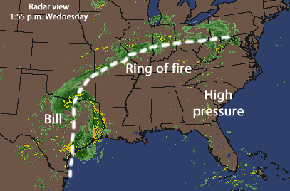
Tropical storm Bill has packed his bags and left Texas to make his way to the east coast… just in time to greet us when we prepare to depart this weekend! Not to fear though, since we have a crew of senior level-headers on board that’ll play it safe.
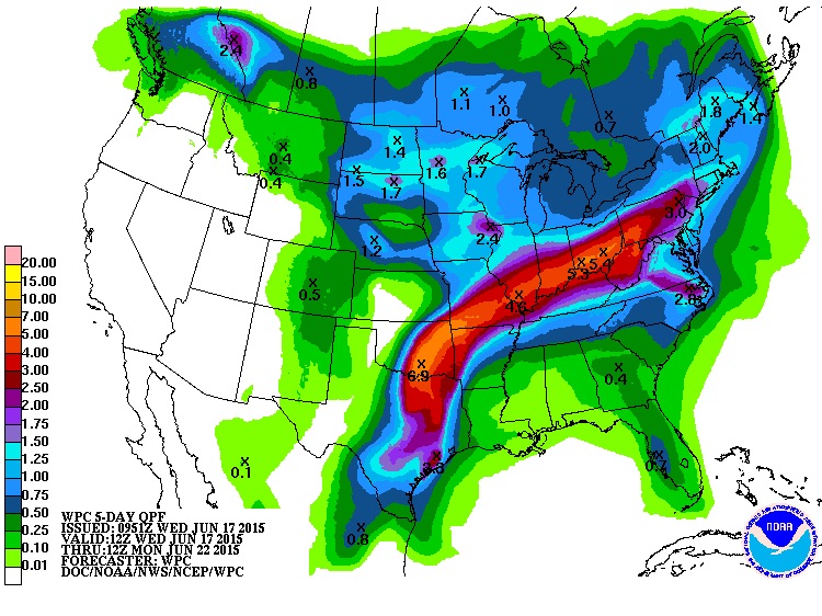
National Weather Service Model
The computer model from the National Weather Service shows the potential for at least 1-2 inches of rain through Sunday. The storms will loose some of it’s oomph but it’ll no doubt be wet! A high pressure heat dome to the south of us will hopefully push Bill to the northeast creating what’s known as a “ring of fire” (meaning daily chances for storms and/or showers). Sure hate to wish it on my Looper friends that have been stuck in the Erie Canal for days waiting for locks to reopen, but go north Bill!
Here sits FRIENDSHIP as located on the Marine Traffic app. If you have the app search for MMIS #367671390 and you can travel with us during the next week. We’ll be arriving at the boat tomorrow, Friday, and will depart on Saturday, June 20 after a day of preparation.
Today Jeff surprised us with some photos of FRIENDSHIP sitting patiently in her slip waiting for her next adventure. Jeff was at the marina (midway through the school’s two-day docking class).
Later on his return home Jeff added, “My wife and I spent last week on sailboats in the Chesapeake and its tributaries, and that has led me to pay close attention to Cap’n Jochen’s advice about clothing. I thought it might be helpful to others for me to tell about our experience. For two days we had blue skies with heat in the 80’s and humidity that caused me to get a bit dehydrated on one day. That was followed byfive days of rain, gray skies, and cold days and nights. Fortunately we were on a boat that had heat. But when we sailed I was envious of my wife’s wool watch cap and long johns (and impressed by her foresight in bringing those for our time on inland waters). I’ll come better prepared for both kinds of weather for our Delmarva circumnavigation.”
We got an early start with crew introductions thanks to web conference technology. Rita introduced Captian Jochen Hoffmann and then had us all introduce ourselves, along with conveying our goals to each other.
Captain Jochen Hoffmann
Following that we covered some basic planning for meals and provisioning and then off we went with questions and answers.